Category Archives: Graphic Apps

Animation Tools, CAD, Converters & Optimizers, Editors, Font Tools, Gallery & Cataloging Tools, Icon Tools, Other, Screen Capture, Viewers

DrawPad Graphic Editor Free 4.00

Type: Freeware
Cost: $0
Size: 4.75 MB
Release date: Feb 05 2018
Platform: Win2000,WinXP,Win7 x32,Win7 x64,Windows 8,Windows 10,WinServer,WinOther,WinVista,WinVista x64
Publisher’s Site:  https://www.nchsoftware.com/inventory/index.html
Publisher’s Product Page:  https://www.nchsoftware.com/drawpad/index.html
Country: United States of America


DrawPad Graphic Editor Free

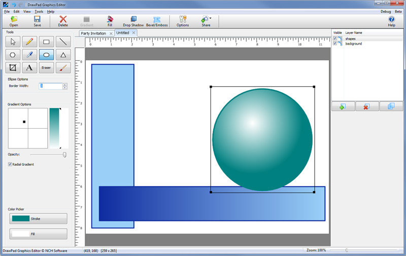
Easily draw and create graphic images with DrawPad – Graphic Design and Drawing software. DrawPad is an easy-to-use image composition and manipulation program, and an essential tool for all types of graphic design projects, including: Creating banner ads or invitations, Make sketches and paintings on your computer, Draw diagrams, icons and other web graphics. DrawPad is ideal for creating images, drawings, and for paintings. DrawPad features pencil and brush tools, raster and vector images, image layers for non-destructive editing, and effects such as bevels and shadows. Fill areas with solid colors, gradients, patterns or textures. Insert shape objects, including circles, rectangles, polygons, stars, word/thought bubbles or insert text. Editing features include crop, rotate, resize, and flip. DrawPad also supports png, bmp, jpg, gif, pdf, and svg formats.
Graphcat<

PDF-XChange Editor 7.0.326.1

Type: Shareware
Cost: $43.50
Size: 142.10 MB
Release date: Jul 25 2018
Platform: Win2000,WinXP,Win7 x32,Win7 x64,Windows 8,Windows 10,WinServer,WinOther,WinVista,WinVista x64
Publisher’s Site:  https://www.tracker-software.com
Publisher’s Product Page:  http://www.tracker-software.com/product/pdf-xchange-editor
Country: Canada


PDF-XChange Editor

Full Page Text Content Editing, Extended OCR options – OCR, Spellchecker, Expanded XFA forms support, Listen/add audio comments, View embedded Multimedia support, Significantly improved rendering and page load speed, New Extended Digital Signature Support, PDF Security Support, Add Comments and Annotations, Add & apply Custom Stamps, Direct Content Editing (Paths & Images), Combine PDFs open/closed pdfs, Import Directly from XPS and other support formats, Bates Numbering, Send PDF files via email, Crop/Insert/Delete Pages, Scan Direct to PDF, Compatible with Windows XP and later, Plug-Ins for both MS IE or Firefox Browser’s; OCR; ‘Autosave’; touch screen mode; multilanguage support; Google Drive, SharePoint; Ribbon/Classic UI

HoudahGeo 5.2.2

Type: Demo
Cost: $39
Size: 22.87 MB
Release date: May 25 2018
Platform: Mac OS X
Publisher’s Site:  https://www.houdah.com
Publisher’s Product Page:  https://www.houdah.com/houdahGeo/
Country: Luxembourg


HoudahGeo

HoudahGeo is a photo geocoding and geotagging tool for Mac. Use HoudahGeo to attach GPS coordinates and location names to your photos.


HoudahGeo writes EXIF and XMP geotags to JPEG and RAW image files. This creates a permanent record of where a photo was taken. Just like a GPS-enabled camera.

HoudahGeo is the only application that can both write future-proof GPS tags to original images and add also locations to photos in the Apple Photos, iPhoto and Aperture libraries.

Geotagging with HoudahGeo follows an easy 3-step workflow: Load, Process, then Output.

* Start by loading photos into a HoudahGeo project. Optionally add GPS track logs.
* Use the built-in map to assign or adjust photo locations. Use reverse geocoding to add city, state / province and country names.
* Write location information to the original image files. Export the project for viewing in Google Earth or Google My Maps. Upload to Flickr.

Feature highlights:

* Supports many methods of geocoding: GPS track logs, built-in maps, Google Earth, etc.
* Write GPS data, location names, title, description and keywords to EXIF, XMP and IPTC tags
* Works with JPEG as well as a large number of RAW file formats. It also supports XMP sidecar files.
* Integrates with Apple Photos, iPhoto, Aperture, and Adobe Lightroom
* Automatic geocoding using GPS track logs
* Geocoding using reference photos taken using iPhone or a GPS camera
* Geocoding without a GPS. Use the built-in map to double-check, adjust, or assign locations to your photos
* Reverse geocoding fills in city, state / province and country names
* Notify Apple Photos, iPhoto or Aperture when places information has been updated
* Create Google Earth KML and KMZ files. View photos pinned along the path travelled
* Publish photos and KML files to Dropbox. Share images on a map
* Upload geotagged photos to Flickr